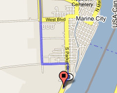
Marine City Boat Access Site
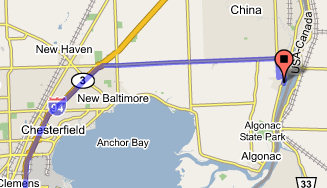
Take the 26 Mile Rd exit 248 to Marine City - go 0.4 mi
Turn right at 26 Mile Rd - go 1.0 mi
Continue on Marine City Hwy - go 11 mi
Turn right at King Rd - go 1.3 mi
Turn left at Chartier Rd - go 0.1 mi
Continue on Chartier Ave - go 0.3 mi
Turn right at S Parker St - go 0.4 mi
Civil Division: Marine City
County: Saint Clair
Coordinates: Lat:42.702649, Lon:-82.500360
Town, Range, Section: 03N, 16E, 12
Waterbody: Saint Clair River
Surface Area (Acres):
Site Rules:
(1) Site Closed 11:00 p.m. to 4:00 a.m.
(2) Fee charged for use of a boating access site administered by
Parks and Recreation
Bureau.
(3) Site closed to all swimming, wading, and bathing.
(4) Special rules apply, such as special closing hours, rules against
consumption of
alcoholic beverages, or others. This designation is
also used where the
site rules are established by an agency other
than the Department of
Natural Resources.
Ramp Description:
A hard-surface ramp with sufficient water depth and lake or impoundment
size to accommodate all trailerable watercraft (minimum of 2.5
- 3 feet
deep at a distance of 20 feet from shore). The site is signed.
Site Administrator:
Algonac S.P.
Contact Number: (810) 765-5605
Total Parking Spaces: 93
Water Craft Controls:
This site has a watercraft control