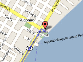
Algonac Municipal
Ramp - Boating Access Site
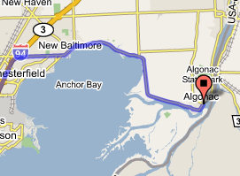
Take exit 243 to New Baltimore (M-29)/Algonac - go 0.5 mi
Turn right at 23 Mile Rd - go 3.8 mi
Continue on Green St - go 2.1 mi
Continue on Dixie Hwy - go 5.0 mi
Continue on Dyke Rd - go 3.2 mi
Continue on Pointe Tremble Rd - go 3.6 mi
Continue on St Clair River Dr - go 0.6 mi
Turn right at Smith St - go 158 ft
Civil Division: Algonac
County: Saint Clair
Coordinates: Lat:42.620021, Lon:-82.528884
Town, Range, Section: 02N, 16E, 10
Waterbody: Saint Clair River
Surface Area (Acres):
Site Rules:
(1) Special rules apply, such as special closing hours, rules against
consumption of
alcoholic beverages, or others. This designation is
also used where the
site rules are established by an agency other
than the Department of
Natural Resources.
Ramp Description:
A hard-surface ramp with sufficient water depth and lake or
impoundment size to
accommodate all trailerable watercraft
(minimum of 2.5 - 3
feet deep at a distance of 20 feet from shore).
The site is signed.
Site Administrator:
Algonac City
Contact Number: (810) 794-9361
Total Parking Spaces: 40
Water Craft Controls:
This site has a watercraft control